Laugavegur Trail: the complete guide for 2026–2027
Everything you need to hike Iceland's Laugavegur Trail: route and stages, huts and camping, season, transport, river crossings, gear and safety — checked for the current season.
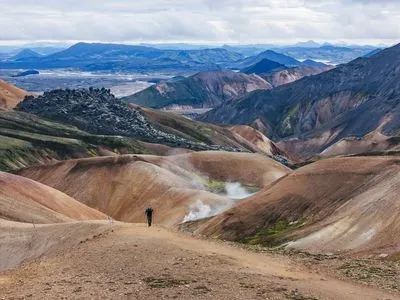
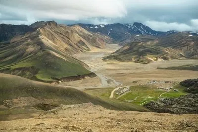
The Laugavegur is Iceland’s most famous multi-day hike — and for good reason. In about 55 kilometres it takes you from the rainbow-coloured rhyolite mountains of Landmannalaugar, over obsidian fields and steaming vents, past glacier views and a turquoise lake, across a black-sand desert and down into the birch woods of Þórsmörk. Most hikers do it in four days, sleeping in mountain huts or at campsites along the way.
This guide gives you the full picture. Each topic links to a more detailed article.
The trail at a glance
| Start → finish | Landmannalaugar (± 600 m) → Þórsmörk (± 200 m) |
| Distance | ± 55 km (Ferðafélag Íslands lists 54–55 km) |
| Duration | 4 days is standard; 3 for fit hikers, 5–6 with side trips |
| Total ascent | ± 500 m up, but much more downhill |
| Highest hut | Hrafntinnusker, ± 1,100 m |
| Season | roughly 25 June – 15 September (depends on snow and road openings) |
| Hut price 2026 | 17,000 ISK per person per night (Ferðafélag Íslands huts) |
| Booking | A hut or campsite booking is required before you set out |
The trail is usually walked north to south, from Landmannalaugar to Þórsmörk. That’s also the direction in which the huts are sold, and it gives you the descent rather than the climb on the long days.
The four classic stages
Day 1 — Landmannalaugar to Hrafntinnusker (12 km, 4–5 h, +470 m)
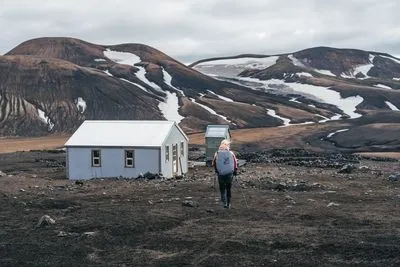
The hardest climb comes first. You leave the hot springs of Landmannalaugar through the Laugahraun lava field, all black obsidian, then climb past Brennisteinsalda, the “sulphur wave”, whose slopes are streaked with yellow, green and red. Higher up, steam vents and snowfields take over. Hrafntinnusker (“obsidian reef”) is the coldest and most exposed hut on the trail and the one where weather matters most — read our weather and safety guide.
Day 2 — Hrafntinnusker to Álftavatn (12 km, 4–5 h, −490 m)
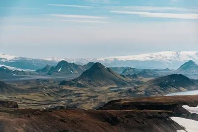
After a high section with views as far as the Mýrdalsjökull and Eyjafjallajökull glaciers, the trail drops steeply down the Jökultungur ridge into a green valley. Your first real ford, Grashagakvísl, comes just before the lake of Álftavatn, where the huts sit on the shore.
Day 3 — Álftavatn to Emstrur (16 km, 6–7 h)
The longest and most varied day. You cross the Bratthálskvísl right after Álftavatn, pass the small hut area at Hvanngil, ford the Bláfjallakvísl and then walk across Mælifellssandur, a vast black-sand desert, with Mýrdalsjökull to your left. The Emstrur (Botnar) huts are tucked into a small green gully.
Day 4 — Emstrur to Þórsmörk (15 km, 6–7 h, −300 m)
The trail follows the rim of the spectacular Markarfljót canyon, crosses the Fremri-Emstruá on a footbridge and then fords the Þröngá, the last river. Suddenly there are birch trees, moss and flowers: welcome to Þórsmörk. Most hikers end at the Langidalur hut, Básar or Húsadalur, where the buses back to Reykjavik leave.
Got energy left? Many hikers add the Fimmvörðuháls pass from Þórsmörk to Skógar — one long, dramatic day between two glaciers, past the 2010 eruption craters.
When to go
The trail is officially open from around 25 June to 15 September. In practice the start depends on when the road to Landmannalaugar opens and how much snow is left. In 2026 the opening came late: Ferðafélag Íslands announced on 2 July that the wardens were in all the huts, with considerable snow still between Landmannalaugar and Álftavatn.
July and August are the most reliable months, but also the busiest. Early September is quieter and often beautiful, with the first autumn colours and a real chance of the first snow. More in Best time to hike the Laugavegur.
Where to sleep: huts or tent
The Iceland Touring Association, Ferðafélag Íslands (FÍ), runs the huts at Landmannalaugar, Hrafntinnusker, Álftavatn, Hvanngil, Emstrur and Langidalur (Þórsmörk). In 2026 a bunk costs 17,000 ISK per person per night. Bring your own sleeping bag. Huts are sold as fixed 3-, 4- and 5-night itineraries and sell out quickly for July and August.
Camping is allowed only at the official campsites next to the huts, and you need to book those too. Wild camping along the trail is not allowed.
→ Laugavegur huts: prices, booking and what to expect → Camping on the Laugavegur
Getting there and back
You can’t drive an ordinary car to Landmannalaugar: the F-roads involve river crossings and need a suitable 4×4. Most hikers take a highland bus from Reykjavik (around 4.5 hours) and return from Þórsmörk the same way. In summer 2026 Reykjavik Excursions ran to Landmannalaugar from 13 June and to Þórsmörk from 1 June, both until 20 September. TREX also runs the route.
→ How to get to Landmannalaugar and back from Þórsmörk
River crossings
You’ll wade through at least three glacial rivers, usually knee-deep and ice-cold. With sandals or neoprene socks and a few simple techniques it’s very doable, but rivers can rise quickly after rain.
→ Laugavegur river crossings: where they are and how to cross safely
What to pack
Waterproofs (jacket and trousers), warm layers, sturdy boots, river shoes, a sleeping bag and enough food for the whole trek — there are no shops on the way. Of the Ferðafélag Íslands huts, only Langidalur in Þórsmörk sells beer and wine.
Safety in one paragraph
The Icelandic highlands can produce winter conditions in July. Check the forecast on vedur.is every day, leave a travel plan with someone at home or use the Safetravel app, listen to the hut wardens and don’t hesitate to wait out bad weather. The emergency number is 112.
→ Weather and safety on the Laugavegur
Go independently or with an organised trip?
The Laugavegur is well marked and many people hike it on their own. The hard parts are logistics: getting hut bookings when they open, matching them to bus times, and carrying everything. If you’d rather not deal with that, an organised trip takes care of the bookings and transport. We compare the options — including self-guided formats where you walk on your own with everything arranged — in Guided or self-guided: how to hike the Laugavegur.
Sources
Hut prices, stages and opening dates: Ferðafélag Íslands. Bus dates: Icelandia / Reykjavik Excursions and TREX. Safety: Safetravel. Always check these before you travel; details can change from season to season.