Weather and safety on the Laugavegur Trail
What weather to expect on the Laugavegur, why Hrafntinnusker is the critical section, and the simple habits that keep you safe in the Icelandic highlands.
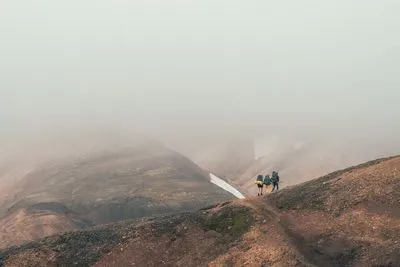
The Laugavegur isn’t technically difficult, but it does cross some of Iceland’s most exposed terrain. Most incidents involve weather, not terrain: fog, wind and cold in the high section between Landmannalaugar and Álftavatn.
What weather to expect
- Temperature: in summer usually between about 5 and 15 °C during the day in the lower sections. At night and around Hrafntinnusker (± 1,100 m) it can drop below freezing, even in July.
- Wind: the biggest factor. Ferðafélag Íslands notes that walking becomes difficult above 10–12 m/s. Storms can be much stronger than that.
- Rain and fog: frequent, and the first two stages are the most prone to dense fog. Visibility can drop to almost zero within minutes.
- Snow: snowfields stay on the high section well into summer, and fresh snow is possible in any month.
The critical section: Hrafntinnusker
The stretch around Hrafntinnusker is high, exposed and often covered in snow and fog. The trail markers can be hard to find. In June 2004 a young Israeli hiker died of exposure in a blizzard, barely a kilometre from the Hrafntinnusker hut. The story is still a reminder that this is a real mountain environment.
Six habits that keep you safe
- Check the forecast every day on vedur.is (or blika.is). Look specifically at wind speed and precipitation for the highlands.
- Leave a travel plan. Tell someone at home your route and expected arrival time, and use the Safetravel app, which can share your location with rescuers.
- Talk to the hut wardens. They know the current conditions, and in dangerous weather they can and will advise you not to set off. Listen to them.
- Navigate with a GPS track. Download an offline map before you go; in fog the marker poles disappear.
- Turn back or wait. There is no shame in staying an extra night in a hut. Weather in Iceland often improves within a day.
- Dress for the worst case. Waterproof jacket and trousers, warm layers, hat and gloves, always in your pack. See the packing list.
Volcanoes
The trail runs between two active volcanic systems: Hekla to the north and Katla under the Mýrdalsjökull glacier to the south. We found no volcanic alerts that affected the trail during the 2026 season, but both systems are monitored closely. If an alert is issued, Icelandic Civil Protection and Safetravel will publish instructions and close areas if necessary.
In an emergency
- Call 112. It works on all networks wherever there is coverage, and coverage on the trail is patchy.
- Share your GPS location via the Safetravel app.
- Stay together, find shelter from the wind, put on all your layers and use your emergency blanket.
Prefer to walk with a guide?
The trail is walked by thousands of independent hikers every year, but walking with a guide gives some people extra peace of mind, especially early in the season or on a first trek in the highlands. See guided or self-guided for the options.
Sources
FÍ – Laugavegur, Safetravel, Icelandic Met Office, Reykjavík Grapevine – Searching for Ido.